
Becoming an InSAR Pro

Train up your team to leverage InSAR data, deploy reflectors, and become operational with our SarProZ platform.
Click to Navigate:

Online Training courses
We offer entire curriculum, materials, and courses that allow you to engage with training on your own time.
Training together is the key to our success. The more you are empowered to leverage InSAR and EO59 systems the higher we will reach, and we are already 2000km in the sky.
In Person Training
Nothing beats collaborating and finding a way through some of the toughest challenges of InSAR together.


SarProZ
Systems Training
An advanced two weeks long series of virtual sessions focusing on SAR and SAR interferometry.
At the conclusion of which you will be able to operate SarProZ to develop and process your own data.

Ground subsidence in Shanghai as analyzed by RASER using Cosmo data and the Sarproz software. Blue indicates stable terrain. Yellow color highlights ground compaction. Yellow strips reveal tunnels excavated under the ground for building subway lines (which caused a localized ground subsidence of the terrain above the tunnels).
The Sarproz-based training course on Synthetic Aperture Radar (SAR), SAR interferometry (InSAR) and Advanced Differential SAR Interferometry (A-DInSAR). The course has been designed to teach the basic concepts behind SAR and InSAR and at the same time to train the participants to reading, processing and understanding SAR/InSAR/A-DInSAR data.
The course will comprise theoretical lectures and tutorials. The whole course will be held online and the tutorials will be based on the use of the Sarproz software together with real data acquired over various areas in the world by most of the existing satellites (Sentinel-1, TerraSAR-X, COSMO-SkyMed, ALOS, Envisat and more).
The program presents for each day a topic treated both in the theoretical aspects and with practical exercises. Each topic is designed to learn particular objectives. Application examples are listed as well to give an idea about the usefulness of each topic. The course will be held online, for a total of 10 days (theory and practice) according to the following structure (more details later in the document):

The SARPROZ software. SARPROZ has a Graphic User Interface allowing anybody using it, even with basic technical knowledge and understanding. At the same time, SARPROZ offers a wide range of options for advanced users, resulting in the best available tool for SAR/InSAR data processing.
1. Basic Module (SAR principles and DInSAR) – Week 1 (Monday-Friday)
2. Advanced Module (Multi-image Advanced DInSAR/A-DInSAR) – Week 2 (Monday-Friday)
Tutorials will be taught using the software Sarproz. Trainees will process real data acquired by various satellites over different areas in the world.
One Sarproz license will be provided for each participant for the whole course duration plus an additional month after the end of the course, to allow the trainees to keep practicing. Students will need to install the software on their own computers to perform the exercises on real data during the course. Sample data will be distributed as well.
Course structure
Next online course: May 2025 - dates available!
Week 1 - Basic Module: May 5-9 2025
Week 2 - Advanced Module: May 19-23 2025
Week 1 - Basic Module
SAR principles and DInSAR
Day 1 - Introduction to the SAR data: basic characteristics and data access.
Objectives:
understanding the basic concepts behind remote sensing, RADAR and the Synthetic Aperture Radar (SAR) technologies;
learning the main characteristics of satellite SAR images and main SAR satellite missions.
Learning how to search and select satellite SAR images from the archives;
how to download free satellite SAR images;
how to download useful ancillary open data.
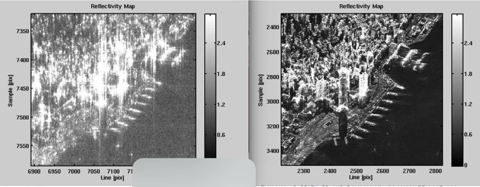
SAR images over the Hong Kong harbor. Left: ALOS (L-band) image, right: TerraSAR(X-band). The two bands have different resolution and highlight different levels of details
Day 2 - How to handle and correctly observe the SAR data
Objectives:
becoming able to import SAR images,
visualize them, geocode them and export them into geographic data visualization software.
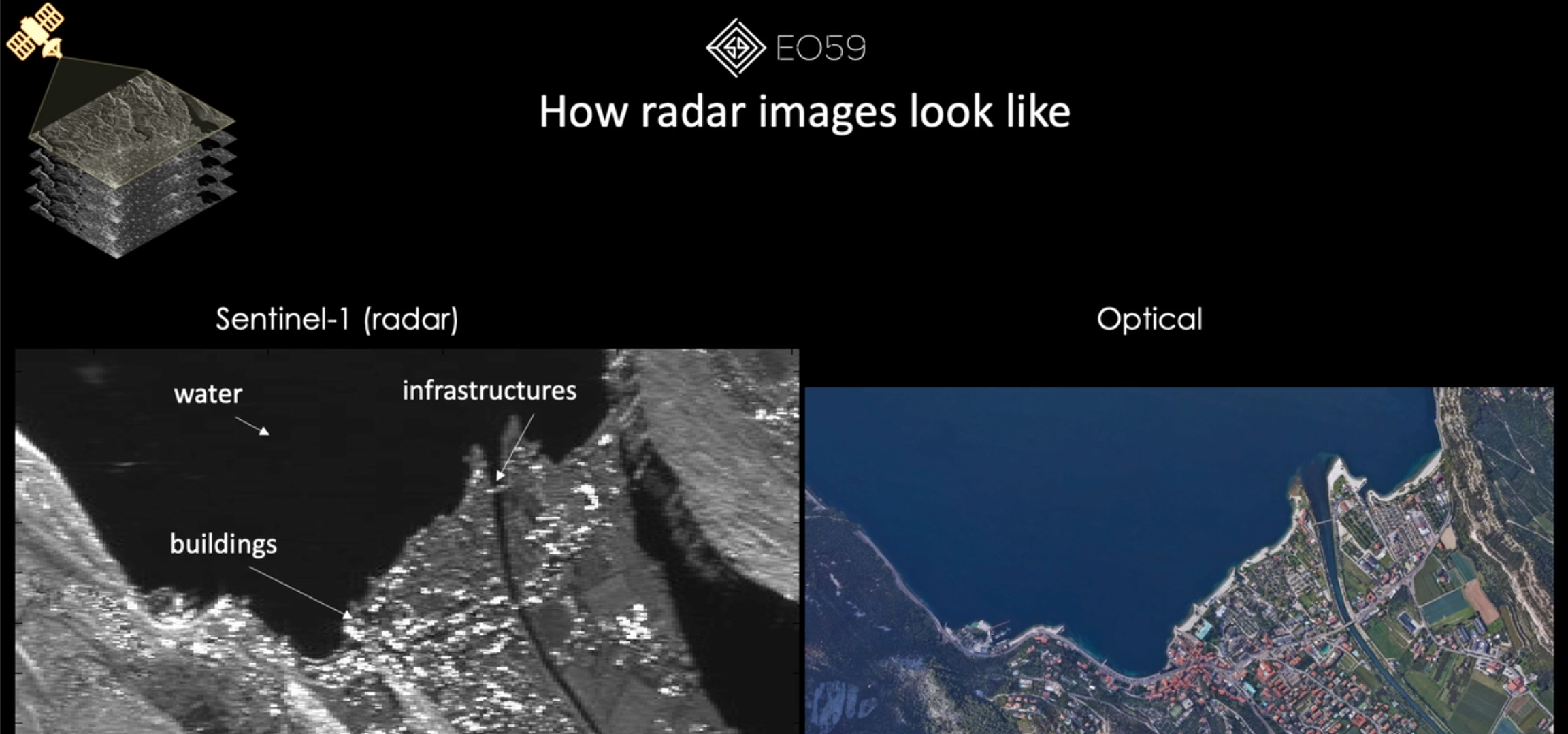
interpreting SAR images;
finding targets in SAR images even when not visible in optical ones.
Day 3 - Change detection
Objectives:
understanding the basic concepts of reflectivity changes
understanding the basic concepts of change detection operations
becoming able to carry out basic change detection processing,
interpretation and results exportation.
Day 4 - SAR Interferometry (part 1)
Objectives:
learning the basic concepts of phase of electromagnetic waves and interferometry,
learning how to interpret interferograms, how to process interferograms and extract topography.
Day 5 - SAR Interferometry (part 2)
Objectives:
learning the basic concepts of Differential SAR Interferometry (DInSAR),
learning how to process and interpret differential interferograms,
how to extract movement information, coherent change detection.
generation of ground displacement maps (e.g. landslides, subsidence, earthquakes),
detection of microscopic terrain changes.

Example of interferogram of a crater in a desert area: with flat earth component (a) and the same interferogram aftertheflattening process.
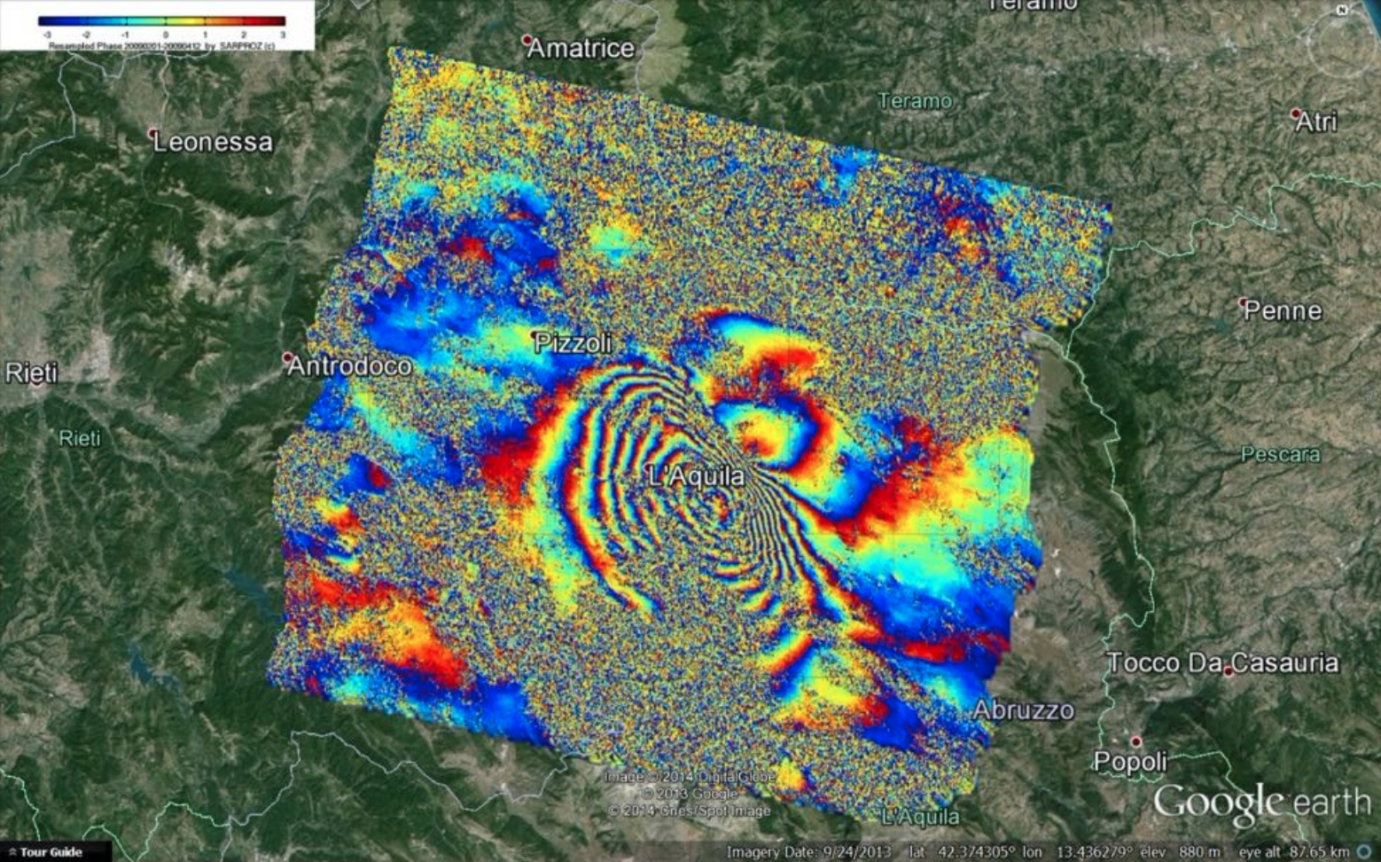
Example of geocoded Differential Interferogram produced by Sarproz using Envisat images (20090201-20090412) showing the displacement caused by L’Aquila Earthquake in Italy.
Week 2 - Advanced Module
Multi-image Advanced DInSAR (A-DInSAR)
Day 1 - Multi-Image AdvancedDifferential SAR Interferometry(A-DInSAR)in Small areas (part 1)
Objectives:
learning the basic concepts of InSARtime series analysis,
how to process time series and estimate targets height and movementin Small Areas.
detection of buildings/infrastructure movements, estimation of buildings height.
Day 3 - Multi-Temporal SAR Interferometry in large areas (part 1)
Objectives:
understanding the A-DInSAR limitations(atmosphere interference),
learning to estimate the long-term linear deformation and the height parameters of point scatterers in large areas.
detection and measurement of wide and localized subsidence processes by using multi-temporal SAR images acquired by a high-resolution SAR sensor.
Day 2 - Multi-Image Advanced Differential SAR Interferometry (A-DInSAR) in Small areas (part 2)
Objectives:
learning to deal with advanced cases: non-linear deformation processes, estimation of thermal deformations, temporary scatterers in Small Areas.
detection of buildings/infrastructure movements affected by non-linear behaviour in time, estimation of cyclical deformation due to thermal expansion, detection of new constructions/demolitions.

Example of time series of a detected target in Hong Kong, using TerraSAR-X data. The upper time series shows the amplitude of the signal reflected by the target. The signal has a sudden drop at the beginning of 2010, when the building collapsed. The lower time series shows that, before collapsing, the building had an acceleration, highlighting that the building was affected by stability problems (data processed by Sarproz).
Day 4 - Multi-Temporal SAR Interferometry in large areas (part 2)
Objectives:
learning to estimate the long-term deformation and the height parameters of point scatterers in a complex urban context.
estimation of movement and height of scatterers in areas with targets characterized by complex geometry and behaviours (high-rise buildings).
Day 5 - Multi-Temporal SAR Interferometry in large areas (part 3)
Objectives:
learning to performA-DInSAR analyses related to ground deformation processes in non-urban areaaffecting natural and non-natural scatterers.
inversion in the space with complex and spatially differential deformation behaviors
inferground displacement processes potentially affected by nonlinearbehaviorin time.