
The Chesapeake Bay's Receding Shoreline
Hello everyone! This post is the first part of a series that will be focusing on the Chesapeake Bay as a current benefactor to use InSAR as an additional tool. This, for a change, will not be technical but rather a collection of real stories that show why this technique is important.
The River House
The Chesapeake Bay is the largest estuary in the U.S. with over 4,047 hectares of tidal shoreline, and is a place held close to my heart. The coastal topography varies from low, marshy land to dramatic cliffs as high as 46 meters above the water, drawing in millions of people every year to the shores of Maryland and Virginia. These shorelines have been heavily influenced by our growing population, as more and more people want to live by the water. Residential and commercial developments are increasing and reshaping this coast every day.
Growing up in Virginia, I spent most of my childhood weekends at my family’s river house on a narrow spit by the mouth of the Potomac River adjacent to the Chesapeake Bay. As beautiful as it is there, a lot is changing, and I fear that our little slice of heaven will not be there for much longer.
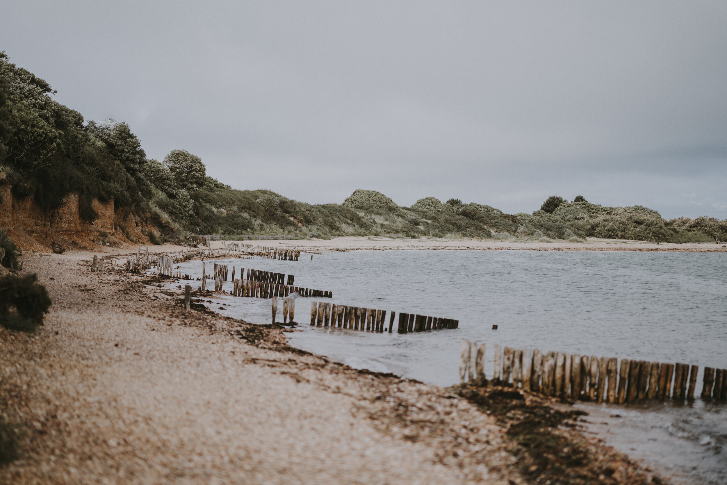
The beach we used to play on has vanished, and all that’s left is the vertical wooden bulkhead separating land from water. Persistent wind-driven waves smash into the bulkhead, exposing soil as it spills over into the yard. The road, as well as our garage, is flooded frequently. Our property is slowly washing away as the shoreline recedes.

This is an aerial photo of my family’s river house and the peninsula it sits on. The green arrow indicates our house; the red arrow shows our portion of the shoreline that’s separated by groins; the blue arrow indicates a groin separating our missing beach from the neighbor’s. If you look closely at the left edge of the shoreline, you can see that the grass is dead from salt water waves frequently crashing over the bulkhead.
** Keep in mind, this picture was taken during high tide; high winds, storm surge or a spring tide would cause the peninsula to flood.
The Vanishing Act
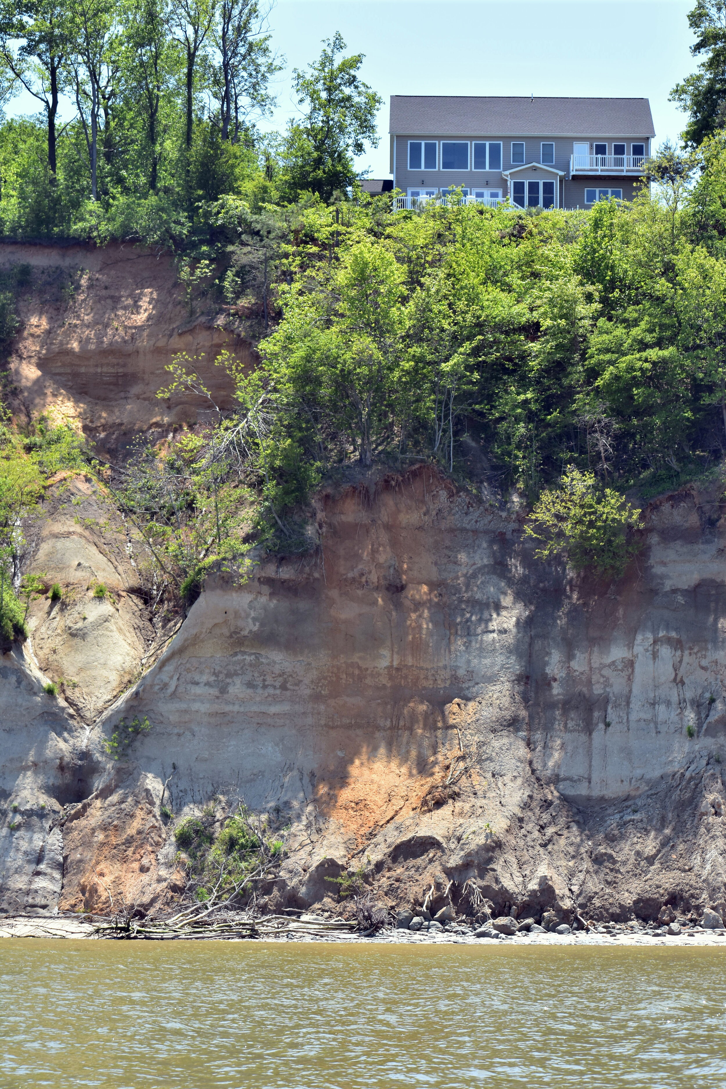
Erosion is occurring on almost every tidal front here, with some circumstances more extreme than others. Not far up the river from my family’s house, 46 meters above the water overlooking the Potomac is a residential development called Stratford Harbour. It sits one meter alongshore Nomini Cliffs in Westmoreland County. At the foot of the cliff banks, powerful undercutting waves actively erode the bluffs about one meter every year. In 2003, a section 90 meters wide separated and slid into the river. This landslide put the houses sitting above the cliffs even closer to the edge. The residents that once had a distant, picturesque view, are now placed only a few meters away from the top of an unstable ledge (see image gallery below).
The southeastern part of Maryland has similar coastal features. It’s estimated that Maryland loses 105 hectares of shoreline a year, 2,158 kilometers lost through erosion, with 605 of them losing more than one meter of shoreline every year (Maryland Confronts Receding Shoreline, 1999). The natural process of erosion takes a long time, so why is so much land disappearing so quickly?


What’s There to Lose?
The Virginia Institute of Marine Science says that about 85% of the Chesapeake Bay shoreline is privately owned. More than 688 hectares of tidal shoreline in Maryland and Virginia have been hardened with artificial shoreline infrastructures, just like our failing bulkhead, in desperate efforts to battle erosion. Recent research has found that these infrastructures have an adverse effect, accelerating the rate of erosion on a larger scale rather than slowing it down.
Losing the protective beach/marsh sitting between communities and tidal waters exposes critical infrastructure, businesses and homes to detrimental damage. Erosion potential decreases the value of these waterfront properties, and the land that washes away cannot be restored to what it was before. Investments are lost as these properties continue to diminish.
Saving What’s Left
Erosion will affect waterfront property owners, as well as the many industries grounded in this region. Sediment from erosion floating in the water column will harm blue crab and oyster populations, affecting the thousands of watermen that rely on them to make a living. Waterfront businesses such as hotels and restaurants will eventually put in great efforts to try and hold the ground that is supporting them.
These at-risk coastal communities require and deserve our attention. Simply put, the way we manage the coastal region is more of an ‘every community for themselves’ approach. With this approach, how do these communities know when actions need to be taken without reliable resources?
InSAR could be used to observe land movement in the Chesapeake Bay region, monitoring and detecting slight shifts in infrastructures along the shore. Evaluating the data and establishing trends could clarify what’s to come when the erosion process is accelerated.
The lands surrounding the Chesapeake Bay are tied very closely to the people calling it home. It’s rich in history and culture, and home to a great diversity of life. To slowly watch the disappearance of a place as special as this, is heartbreaking. With InSAR painting the picture with data, it could become the helping hand that is missing here.
Our guest author, Brooke Haas

Brooke Haas is an educator and writer based in Roanoke, VA. She has worked on both research vessels and oyster boats and holds a B.S. in Biology from Old Dominion University.